Pages

Thursday, October 29, 2020

Petra: Why it is Deemed one of the 7 Ancient Wonders of the World

Today, our journey takes us to the Near East to the ancient Nabatean city of Petra. We will be heading south from Amman, Jordan to an area below the Dead Sea. Petra had been on my bucket list for years, so I approached it with great enthusiasm.

Nothing could have prepared me for the breath-taking awe of the 2.7-mile (4.3 km) walk through narrow red sandstone canyons and open spaces. The city is magnificent in scope and astounds the mind to consider how the ancients built their facades, most of which today are burial sites that have survived. They even had a sophisticated system of collecting water and using hydraulics to insure they had a year-round water supply in an arid desert climate.

Donna and husband Jim entering the main avenue of Petra

Nabatean Water Channel to Supply the City

Leaving the Canyon into the Treasury Area

The Treasury

In 2007, more than 100 million people voted Petra as one of the new 7 Wonders of the World. Most people associate this archaeological site with the 1989 film Indiana Jones and The Last Crusade. Still, by far, it's the historical drama that unfolded in the region and the rise of the Nabatean culture that captures the imagination, regarding this once vibrant capital city.

Prior to the 6th century B.C. when the Nabateans first arrived, the region already experienced a colorful history. The Bible recounts in Genesis 25 – 27 that Abraham’s son Isaac had twin sons, Jacob and Esau. A tense relationship existed between them, and because of Esau’s impetuous nature, he lost his birthright. He fled to the area in southwest Jordan between the Dead Sea and the Gulf of Aqaba and established the Kingdom of Edom. (Of note: Esau's name and Edom both mean "red" in Hebrew--Esau's complexion having been ruddy and the region composed of red sandstone.)

During the Exodus (most accepted to be around 13th - 12th century B.C.), the route taken by Moses led them through Edom. A place here has been marked as the rock that Moses struck and drew water from in Exodus 17 and is called Moses' Spring or Ayoun Mousa.

Edom thrived between the 13th to 8th centuries B.C., most notably controlling the King's Highway and collecting tribute from traveling merchants. However, in the next two centuries, Edom experienced a period of decline until the sixth century when the Babylonians demolished it--a biblical prophecy foretold long before Edom's downfall. (See Jeremiah 49:7 - 22, Ezekiel 25:12 - 14; 35:1 - 15, Amos 1:11 - 12, Isaiah 21:11 - 12, and Obadiah 1:1 - 14.)

Beginning in the sixth century B.C., the Nabateans--a Bedouin nomadic tribe--migrated from Arabia. Over time, they gave up the nomadic lifestyle, gained the Edomites' lucrative trade routes, and carved edifices into the red sandstone region, most predominantly in the capital city, they called Raqmu (Petra).

The Royal Tombs

The Nabateans prospered for centuries, acquiring wealth and power as caravan merchants and controlled the Transjordan into Syria. In 2 Corinthians 11:32 - 33, we read that Paul had to sneak out of Damascus in a basket through a window to escape from the ethnarch under King Aretas, who was a Nabatean.

The Nabateans maintained a peaceful co-existence with Rome for several centuries until 106 A.D., when Rome took complete rule of the region. Earthquakes in 363 and 747 A.D. severely damaged Petra, and the Bedouin who remained protected Petra from outsiders for more than 1,000 years.

Then in 1812, a Swiss explorer, Johann Ludwig Burckhardt, took on the alias of a devout Muslim, and under the auspices of making a pilgrimage was given access to the ancient city. He published his find, and slowly Europeans flocked to see the wondrous site. The deception caused a great disdain for foreigners by the Bedouins for many years afterward.

Today, the Bedouin welcome visitors to the region, selling their wares along the avenue of a city that once was a thriving metropolis. It is truly worthy of being called one of the 7 Wonders of the World.
Donna in the Background, Surveying the Souveniers


Wednesday, October 21, 2020

Guadix: A City of Cave Dwellers in Southern Spain

Have you ever wondered what it would be like to live underground? 

Today in my History, Travel, and Adventure Blog, I switch directions back to Europe and take us to a lesser-known, but no less fascinating place in the Andalucían province of Granada, Spain.
 
Located on a plateau at almost 3,000 feet (913 meters) in the shadow of the Sierra Nevada is the city of Guadix. The city’s history goes back to ancient Roman times, and sources say Julius Caesar founded Guadix to mine the craggy ochre hills for silver. He called the town Julia Gemella Acci, and residents today are still called Accitanos.

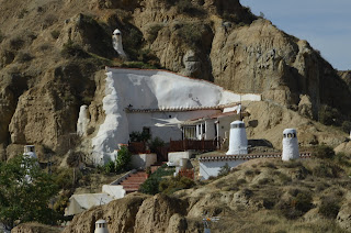
However, it’s the Barrio de las Cuevas or Neighborhood of Caves that draws awe and wonder and compels one to stop and stare and explore what lays beneath the surface of this community. For amidst a dry, rugged landscape, a moon-like topography dotted with white chimneys, poking through the earth, gives evidence of a people known as the troglodytes, who have made their homes in caves for more than five hundred years. But what drove them underground?

Barrio de las Cuevas  

Barrio de las Cuevas

From the 8th to the 15th centuries, much of Spain was under Moorish rule. After several civil wars, Guadix became an important capital of a Moorish kingdom under El Zagal at the end of the Nasrid Dynasty. But in 1492, Granada fell to Catholic Spain, and the town was conquered. At the beginning of the seventeenth century, the Moors were expelled from Spain, and it's said that many took refuge in the caves around Guadix.

Today, almost 19,000 people live in Guadix, many of them inhabiting 4,000 caves as permanent homes in and closeby to the town. An attraction to living underground is a year 'round temperature of sixty-six degrees Fahrenheit (19 degrees Celsius) in an arid climate that can reach the high 90s F in summer (35 c) and get down to the low 20's (-6 c) in winter. Rather than a dank, dark environment, the caves have been modernized, some of them turned into luxurious dwellings, and some have even been converted into hotel accommodations for visitors who would like the experience. The area is considered to have the biggest concentration of inhabited caves in Europe. 

When we visited, my friend Cristina and I toured one of the caves, owned by a sweet man whose name is Jose. Friendly and excited to show us through his home, he led us through quite comfortable and homey rooms that include an up-to-date kitchen, living room, dining room, bathroom, and displayed pictures of his family. When we asked if he would live anywhere else, he said no. His ancestors have lived in this particular cave for generations, and he couldn't imagine living anywhere else. And I can see why. He has everything he needs, and then some.


Jose Welcoming us at the Front Door

                                                          The Front of Jose's Home

Donna in the Foyer of Jose's Home

Jose's Living Room

Jose's Neighbor's Home

Besides the intriguing Barrio de las Cuevas, Guadix boasts an impressive cathedral in the heart of the city that combines the three centuries (16th - 18th) of Gothic, Renaissance, and Baroque styles that it took to erect it and the ochre-colored fortress or Alcazaba de Guadix built during the tenth and eleventh centuries by the Moors. Both testify to the captivating contrast of cultures that have contributed to molding Spain into what it is today. 


Left: Guadix Cathedral, Right: Alcazar de Guadix


Wednesday, October 14, 2020

Dingle, Ireland to Georgetown, Colorado and the Rocky Mountains, Part II

Last week, I began a new blog series, focusing on historical and cultural sites around the world that have captivated my interest. I began with a two-part series “From Dingle, Ireland to Georgetown, Colorado,” exploring the Dingle Peninsula where my protagonist, Anna Katherine O’Sullivan had come from in my Singing Silver Mine Trilogy. Today, I’m exploring the glorious majesty of the Colorado Rockies, the immigrants who came to tame them, and the people who populated the territory before the white man moved in.

 While the Dingle Peninsula of County Kerry had the tallest mountains in all Ireland, the tallest peak only rose to thirty-four hundred feet. Yet, as Anna rode south to Denver aboard the Denver Pacific Railway from Cheyenne, Wyoming in October, she would have seen mountains rising to more than fourteen thousand feet formed in ages past by tectonic and glacial activity. Her eyes must have grown as wide as the grand peaks she saw. She wouldn’t have been the first European to feast her eyes on those peaks, however.

View of the Continental Divide from Brown  Mountain near Georgetown--Summer
In the mid-nineteenth century, many of these mountains were denuded to build mines and housing.

                            View of the Continental Divide from Rocky Mountian National Park in October

The Spanish Conquistadores occupied Colorado in the seventeenth-century and annexed it into the province of Santa Fe de Nuevo México as part of the Viceroyalty of New Spain.  It wasn’t until 1846 when the United States went to war with Mexico that a treaty was finally reached in 1848, giving the territory to the United States.

Most white settlers avoided the rugged terrain, until 1858 when a party from California discovered gold around Pikes Peak. More than one thousand people converged on the Territory of Colorado to find gold. Within a decade, hard rock gold, silver, and other minerals, including coal, gave impetus for prospecting. Some grew rich; most didn’t. Immigrants from Scandinavia, Scotland, Ireland, Italy, Germany, and Russia provided labor for mining, railroads, and farming. Experts in mining technology from Europe flocked to exploit the land. In August 1876, Colorado officially became the thirty-eight state of the union.

When the Spanish first arrived, they set up a system of trade with Native Americans, and between 1832 - 1856 traders, trappers, and settlers established trading posts along the Arkansas, South Platte, and Sain Vrain Rivers, carrying on a robust trade. Most prominent among them were the Cheyenne, Arapaho, and Ute who lived on the plains and moved west along the Front Range of the Colroado mountains, or in the south near New Mexico. These people had their own colorful culture, customs, and religious traditions.

Yet, with immigration came increased pressures for land and resources. Native Americans were pushed off their lands, their sacred burial grounds trampled, diseases like tuberculosis raged through their tribes, and treaties were signed and broken. Cheyenne and Arapaho joined forces against the calvary as skirmishes took place, the two deadliest being the Sand Creek (1864) and Summit Springs (1869) against the Native Americans. Though eventually Native Americans reluctantly accepted reallocation to reservations, strife continued through the twentieth century. 

In the twenty-first century, great strides have been made to educate people about Native American culture and traditions, such as the Denver Indian Market & Southwest Art Fest held every January to bridge the gap. If the history of humanity teaches us anything, it ought to be to value and respect all human life, created in the image of God, wherever it may be found.

Former Site of Arapaho Camp Ground along the Cache La Poudre River, Fort Collins, CO

Alleged Site of Arapaho Council Tree, Cache La Poudre River, Fort Collins, CO


Wednesday, October 7, 2020

New Blog Series Travels to the Past and Explores Our History

Do you enjoy an adventure? Are you fascinated by people, places, and history? When you travel, do you find yourself exploring every nook and cranny of a place, talking to locals and learning about the culture? When you read books, do find yourself gravitating towards non-fiction on times and eras and events that took place in the past? Or if you read fiction, do you tend to get embroiled in historical novels that bring the past to life?

If you've answered yes to any of these questions, you may find my new blog series resonates with you. Every Wednesday, I will post a piece that explores sites around the world that have captivated my interest because of their unique culture or history. Sometimes I'll address a place or people in one of my novels. Other times, I'll talk about a place, monument, or site on one of my travels that struck me as unique or different. And if you've visited a place you think others might want to learn about, I invite you to write a 350 - 500-word piece as a guest blogger.

Today is the 7th of October, so it's fitting to start with two places that are near and dear to my heart because both are dear to the heart of Anna Katherine O'Sullivan in my new Singing Silver Mine Trilogy. Anna emigrated from Dingle, Ireland in the fall of 1872 to live in the Colorado Rockies and arrived in Georgetown on October 7th. She left the love of her life and the only land she'd ever known because the Irish system of landholding made it impossible for a woman born of poverty to marry well without a dowry, and her aunt in Colorado promised her vast opportunities for life and love waited for her there. But what had she left behind?

The Dingle Peninsula--that remote mountainous finger of western Ireland, jutting into the Atlantic Ocean--is most often associated with the Great Hunger of 1845 - 1851 when the potato blight tragically killed more than a million people in all Ireland by starvation, County Kerry being one of the hardest hit.


Long before the nineteenth century, however, various tribes lived on the Dingle Peninsula for more than 6000 years, passing along their myths and folklore in the ancient Irish language. The peninsula boasts a rich and complex archaeological history with more than 2,000 monuments preserved through the millennia. A several-hour tour along the circular route of Slea Head Drive, beginning and ending in Dingle, provides a most spectacular scenic journey through wild landscape, remote Irish-speaking villages, and historic cultural and archaeological sites. 


The Dingle Peninsula provides you with a sense of awe and inspires the imagination. You can easily understand how hard it would have been for Anna to leave her beloved land.

Next week, I'll explore the grand and glorious majesty of the Colorado Rockies, the immigrants who came to tame them, and the people who populated it long before the white man.